Hydrographic and Scanning Surveys at Coffs Harbour April 2013
McGlashan and Crisp were instructed to;
1. To survey the outer harbour.
2. To survey the marina and entrance to identify any shoaling.
3. To survey the waters to the north and adjacent to the northern seawall connecting to Muttonbird Island.
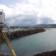
4. To scan the northern side of the northern seawall.
The Hydrographic Survey was carried out using a Ceeducer Pro Survey Fathometer recording depths, heights and position. All height and position data was provided by a Topcon RTK GPS system.
The scanning was completed using a Riegl VZ-1000 laser measurement system to capture the break wall with a total of 13 scans carried out over the course of 1.5 days.